Last of the Divide
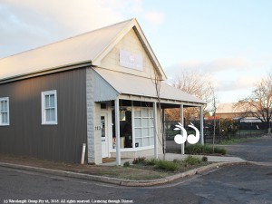
THE small piece of guttering outside the front of a beauty salon in St Aubin’s Street is the last remaining divide in a piece of Scone’s history.

The gutter in front of this building in St Aubins Street is the last demarcation of the private town and the public town of Scone.
It was part of the line between the public town of Scone to the west and the private town of Scone to the east.
The public town of Scone was gazetted by the government in 1836 and is the earliest surviving map of settlement in Scone: Town map from 1836.
The government had planned a township on Kingdon Ponds, but the population shifted east between 1826 and 1834, after William Nowland found a path over the Great Dividing Range; the tracks from his dray through Scone formed the path of of the Great North Road, now known as the New England Highway.
St Aubin’s Arms was built beside the Great North Road to take advantage of the passing trade and is the oldest building in Scone.
The land surrounding the public town of Scone was part of William Dumaresq’s property St Aubin’s and Richard Kelly’s land known as Kelly’s Farm.
Residents of the private town of Scone were people who were employed at St Aubin’s or who rented land from St Aubin’s.
The dividing line between the two sides of town was in the block between Kelly Street and Main Street still marked by a small piece of guttering in St Aubin’s Street.
It also explains why there is a dog leg in Susan Street, that Liverpool street is slightly off centre at the round about on Main Street and why Kingdon Street is not straight.
Hopefully with the new street designs and the proposed park in St Aubin’s Street the small piece of local history will be retained: See page 20 of the Scone Town Centre Masterplan.
 scone.com.au