Hotter and Drier in the Upper Hunter
YESTERDAY the Bureau of Meteorology released their Climate Outlook, which paints a hotter and drier picture for the next three months.
The Bureau has published the report online providing maps of predicted rainfall and temperatures.
A spokesperson from the BOM interpreted the report for the Upper Hunter and gave the following advice:
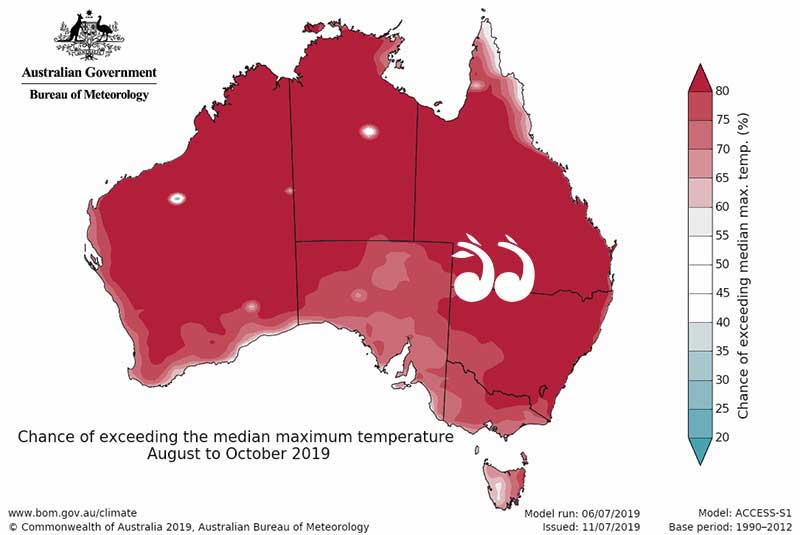
The Bureau predicts warmer than average weather for the next three months.
“On the maximum temperature map it is bright red for all of New South Wales, including the Upper Hunter,” said the spokesperson.
“Afternoon temperatures are likely to be hotter than average and the same is true for minimum temperatures in the Upper Hunter, with temperatures overnight being warmer than average,” she said.
Predicted rainfall:
“On the map, near the coast it is grey and towards the Upper Hunter it becomes orange, as you move from grey to orange that it is more likely to see below average rainfall,” said the BOM spokesperson.
“The chance of getting at least 50ml around Scone over the three months is 70 percent, the chance of getting 100ml is 60 percent and the chance of at least 150ml is about 25 percent,” she said.
“Over three months that is not a lot of rainfall unfortunately,” she said.
The climate drivers for the forecast are a positive Indian Ocean Dipole and an El Niño–Southern Oscillation – neutral tropical Pacific Ocean.
“The Indian Ocean Dipole is the difference in ocean temperature between the west and east tropical ocean, which affects winter and spring rainfall typically in southern and eastern parts of Australia, but breaks down during summer because it is disrupted by the Australian monsoon season,” said the spokesperson.
“ENSO is the amount of warming of the sea’s surface in the central and eastern tropical ocean, when we have warmer temperatures in the tropical pacific ocean it can cause an El-nino patter to develop around autumn, winter and spring and leads to lower than average rainfall across eastern Australia,” she said.
“Some of our driest winters and springs are related to a neutral or strong ENSO and when the temperatures of the ocean surface drop we get higher rainfalls,” the BOM spokesperson said.
Tags: weather